
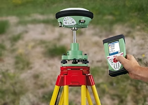
DGPS Land Survey
High-precision positioning using DGPS instruments for accurate control and mapping
What is DGPS Land Survey?
Differential GPS (DGPS) Land Survey is an advanced surveying technique that uses GPS satellite signals with real-time corrections to achieve sub-centimeter accuracy. This technology is essential for establishing precise control networks, boundary surveys, and large-scale mapping projects.
At Hayagriva Associates, we utilize state-of-the-art DGPS equipment to provide highly accurate positioning data for various applications, from property boundaries to infrastructure development projects.
Key Advantages
Why Choose DGPS Surveying?
Advanced technology meets professional expertise for unmatched accuracy
High Precision
Sub-centimeter accuracy using DGPS technology for critical control points
Real-Time Correction
RTK and RTCM corrections for immediate positioning accuracy
Mapping Integration
Seamless integration with GIS, CAD, and drone mapping workflows
Efficient Coverage
Fast data collection over large areas with reduced field time
Common Applications
Where DGPS surveying makes a difference
How We Work
A systematic approach ensuring accuracy at every step
Site Assessment
Evaluation of site conditions and requirements
Control Setup
Establishment of base station and reference points
Data Collection
GPS survey with real-time corrections
Processing & Validation
Quality checks and coordinate transformation
Report Delivery
Comprehensive reports with CAD/GIS deliverables
Ready for a DGPS Survey?
Get accurate, professional DGPS land surveying services. Contact us for a detailed quote and consultation.